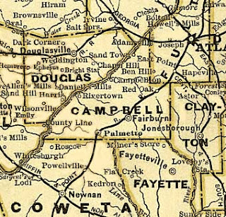
Campbell County was created December 20, 1828 by the Georgia General Assembly from portions of Carroll, Coweta, DeKalb and Fayette counties.
It was named for Duncan G. Campbell who was a lawyer, legislator and one of the few men at the time who thought females should be exposed to higher education. Campbell was also involved in the 1825 treaty with the Creek Nation.
The first map I'm posting here is from 1830. I put this image up on the blog's Facebook last week to show how Trout Creek is noted on the present-day Douglas side of the Chattahoochee River. Today we know the creek as the Dog River.
By 1830, the population of Campbell County had reached a little over 3,300, and by 1835, streets and lots were surveyed and staked out. Construction had started on a brick courthouse and jail.
A rather quirky feature of the map below is it indicates Campbellton was on the opposite side of the Chattahoochee. That's wrong. All of the town was on the southern side of the river.
During the 1830s and 1840s Campbell County officials attempted to improve roads to connect nearby communities. Rivertown (Pumpkintown) and County Line (Redwine) became post office stops. Other communities sprang up such as Rico, Goodes and Friendship.
Look at the map below from 1855. Notice on the north side of the river - today's Douglas County - the community of Dark Corner is noted, and at least this time Campbellton is on the proper side of the river.
By 1860, the population of Campbell County was over 8,500. Georgia passed its Ordinance of Secession January 18, 1861. Almost immediately over 1100 Campbell County men enlisted in various volunteer regiments.
Notice on the 1863 map I've posted below Salt Springs and Holly Springs appear for the first time across the river.
The 1864 map I've posted below includes two factories - the Sweetwater Factory we know as New Manchester - and another "cotton factory". Notice Trout Creek has disappeared and Dog River is in its place. Bear Creek is finally noted through it had always been there.
The final map I've included is from 1883. Douglas County formed in 1870 and took all of the land on the opposite side of the river along with some of what had been Carroll County.
Following the Civil War, Campbell County, like so many other Georgia counties had to deal with loss - loss with so many men who didn't return and loss from the effects of skirmishes that occurred in July, 1864 as Union forces crossed the Chattahoochee River as they headed south.
After the war the focus turned to Fairburn as it became the new county seat mainly due to the placement of the railroad.
It is interesting to note on the 1883 map (below) Douglas County appears. Within Douglas County you can still see the community of Dark Corner, the railroad through Douglasville and the community of Weddington which would become Winn and later Winston.
What was left of Campbell County would eventually melt into Fulton County by 1932.
I do find it interesting that my hometown of Red Oak was part of Campbell County. I never really thought of that very much. I really haven't moved that far away from roots!


No comments:
Post a Comment